|
Day 17
Valdez, Alaska To Kluane Lake, Canada
Highlights
We grew sick of the rain that followed us for days and decided to begin our journey back to mainland US and opportunistically visit points of interest along the way. The day is mostly about driving and much of it retracing our journey. The main deviation in plan was failing to drive the Top Of The World highway, once again due to road closure. This forced us to drive back to Canada on the same route we had taken on the way to Alaska.
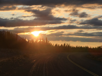
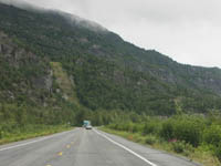
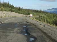
The main exciting things were climbing the Worthington Glacier trail for a closer look and camping by ourselves on the shore of Kluane Lake! The photo at right, while common in comparison with others taken during the trip, reflected our more upbeat mood in seeing the sun again. |
|
Day Journal
| Generally I'd be more tolerant of wet and gloomy weather while at home since I'd have things to do and a comfortable home to stay in, but on the road with the intent to photograph nature it was frustrating. With the last time we saw the sun days ago, and no sign of the rain letting up, we could not really pursue quality outdoor activities. My desire to photograph Alaska wildlife and sceneries was also hampered greatly. So rather than sticking around hoping for better weather, we decided to pack up and head back toward Canada. We had thought of taking a ferry serving the Alaska Marine Highway to Seattle to both see the Inside Passage, and to avoid driving over the same old route. However, this did not materialize due to the long lead time for reservation which could be weeks. In considering the return driving trip, we looked for alternative driving routes. Among new things we wished to do were driving the Top-Of-The- World Highway that we had missed earlier due to road closure, and visiting Skagway, another popular cruise ship destination. Beyond those destinations and now that we had driven the length of the Alaska Highway, we wish to take a shorter and different route by following Highway 37 through the mountains of British Columbia. Those were the things we wished to do, but nature made us do things differently over the coming days. |
|
Backtracking the Richardson Highway |
|
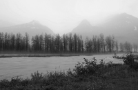 The first part of the drive was backtracking Richardson Highway from Valdez to Glennallen. It was the weather that had prompted us to depart that also played a role along the way. The rain caused us to skip places that we'd otherwise visit such as where we had seen salmon spawning, and yet stopped to capture images of the mountains with mood change from the previous day. This photo of Lowe River and Chugach mountains in the background was rendered in black and white since the mood with low clouds is more suitable than color rendition. The first part of the drive was backtracking Richardson Highway from Valdez to Glennallen. It was the weather that had prompted us to depart that also played a role along the way. The rain caused us to skip places that we'd otherwise visit such as where we had seen salmon spawning, and yet stopped to capture images of the mountains with mood change from the previous day. This photo of Lowe River and Chugach mountains in the background was rendered in black and white since the mood with low clouds is more suitable than color rendition. |
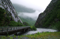 In the Keystone Canyon, we made longer stops at Bridalveil and Horseshoe falls and then at the Old Railroad Tunnel. The waterfalls were then partially hidden behind low clouds, rendering an even dreamier mood than we had seen. Despite the hassle of donning on raincoat and using umbrella to protect camera gears from the elements, I managed to put a few more images of these falls on memory cards. But I must admit that the best pictures of the falls were taken by my wife on an inexpensive camera that captured more completely the overall mood of the place and with me in the picture for a sense of scale. The Old Railroad Tunnel had quite a history involving gunfights which ultimately stopped it from completion. In the Keystone Canyon, we made longer stops at Bridalveil and Horseshoe falls and then at the Old Railroad Tunnel. The waterfalls were then partially hidden behind low clouds, rendering an even dreamier mood than we had seen. Despite the hassle of donning on raincoat and using umbrella to protect camera gears from the elements, I managed to put a few more images of these falls on memory cards. But I must admit that the best pictures of the falls were taken by my wife on an inexpensive camera that captured more completely the overall mood of the place and with me in the picture for a sense of scale. The Old Railroad Tunnel had quite a history involving gunfights which ultimately stopped it from completion. |
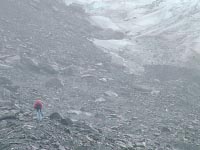 Aside from the wet road condition dictating a slower pace, the drive on Thompson Pass was particularly hazardous due to winding mountain roads and low visibility which at times dropped to yards. The same condition persisted when we reached Worthington Glacier, with the glacier barely visible behind the clouds. I had wanted to follow the trail I had seen two hikers climbed up the side of the glacier the day before. With the poor weather, my wife wisely declined to follow me on the trek. Whatever trail that might be visible were not apparent to me as I tried to climb up, and thus more or less made my own trail on the loose and slippery rocks. Carrying umbrella, tripod, camera backpack among other things made the hike up quite awkward. Furthermore, it was quite difficult to get decent images out of that poor lighting. I wound up abandoning the climb half way up. Aside from the wet road condition dictating a slower pace, the drive on Thompson Pass was particularly hazardous due to winding mountain roads and low visibility which at times dropped to yards. The same condition persisted when we reached Worthington Glacier, with the glacier barely visible behind the clouds. I had wanted to follow the trail I had seen two hikers climbed up the side of the glacier the day before. With the poor weather, my wife wisely declined to follow me on the trek. Whatever trail that might be visible were not apparent to me as I tried to climb up, and thus more or less made my own trail on the loose and slippery rocks. Carrying umbrella, tripod, camera backpack among other things made the hike up quite awkward. Furthermore, it was quite difficult to get decent images out of that poor lighting. I wound up abandoning the climb half way up. |
|
| The remaining drive back to Glennallen beyond the mountain section was uninteresting. By the time we reached the Kennecott Turn Off, we decided to skip the drive to the interior of Wrangle-St. Elias since we assumed that whatever warnings the ranger gave us the day before about driving on that dirt road would likely be worse with all the extra rainfall. |
|
Tok Cut-Off Highway |
|
 When we reached Glennallen, we embarked on the only new journey of the day by following the Tok Cut-Off Road (also known as an extension to the Glenn Highway) to Tok. This road which connects Glennallen with Tok directly, cuts some 120 miles from the same trip before the road was built. We were certainly grateful not having to drive through the boring section to Delta Junction and then to Tok. The Tok Cut-Off road was an interesting drive which also borders the national park, thus offering great views of the mountains. When we reached Glennallen, we embarked on the only new journey of the day by following the Tok Cut-Off Road (also known as an extension to the Glenn Highway) to Tok. This road which connects Glennallen with Tok directly, cuts some 120 miles from the same trip before the road was built. We were certainly grateful not having to drive through the boring section to Delta Junction and then to Tok. The Tok Cut-Off road was an interesting drive which also borders the national park, thus offering great views of the mountains.
|
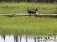 It was on this road that we saw a female moose feeding in the pond. Despite their size and appearance, there is something graceful and peaceful about this image. Perhaps she was all by herself, or perhaps it was the tranquil setting with glassy pond surface and no other sound aside from my camera shutter closing. This is among many photos that I wish I could do over again. It was on this road that we saw a female moose feeding in the pond. Despite their size and appearance, there is something graceful and peaceful about this image. Perhaps she was all by herself, or perhaps it was the tranquil setting with glassy pond surface and no other sound aside from my camera shutter closing. This is among many photos that I wish I could do over again.
|
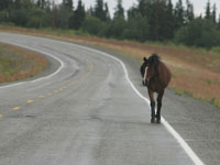 It was also on this section of the road that we had to put on our break for a beautiful horse casually strolling along the highway. There was nothing on the horse to suggest it's owned by someone, but yet it looked too casual to consider it a wild horse. Our best guest was that it came from some ranch that we could not see. It was also on this section of the road that we had to put on our break for a beautiful horse casually strolling along the highway. There was nothing on the horse to suggest it's owned by someone, but yet it looked too casual to consider it a wild horse. Our best guest was that it came from some ranch that we could not see.
|
|
The road leveled off when we approached Tok. Upon arriving, we returned to the same visitor center that we had visited days earlier to check about the condition of the Top Of The World Highway, and to our dismay, the road was still closed due to some mudslides weeks earlier. With that bad news, we had no choice but to retrace our drive back on Alaska Highway to Beaver Creek, Canada. |
|
Tok To Kluane Lake, Canada |
|
|
|
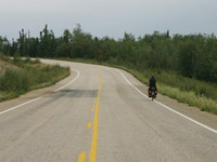 If there was one stretch of road that we dread driving during the journey, the section from Tok to western Canada would be it. The road condition is quite poor due to permafrost and lack of maintenance, especially on the Canadian side. The scenery while fairly interesting is fairly common along the highway. Those who have the time to venture into the wilderness would likely find interesting things to do, but we certainly did not have that luxury. With our route set for us, we decided to drive as far as we could to shorten the time on the Alaska Highway. The only thing that impressed us along this long stretch of road was to find occasional bicyclists crossing the border, and probably riding hundreds of miles between cities. If there was one stretch of road that we dread driving during the journey, the section from Tok to western Canada would be it. The road condition is quite poor due to permafrost and lack of maintenance, especially on the Canadian side. The scenery while fairly interesting is fairly common along the highway. Those who have the time to venture into the wilderness would likely find interesting things to do, but we certainly did not have that luxury. With our route set for us, we decided to drive as far as we could to shorten the time on the Alaska Highway. The only thing that impressed us along this long stretch of road was to find occasional bicyclists crossing the border, and probably riding hundreds of miles between cities.
|
 The rain returned briefly, but also quickly dissipated much to our relief. We returned to the same restaurant that we had breakfast in Beaver Creek, this time for dinner. We mused that we had not considered having meals at the same restaurant twice on this long journey. With the sun still high after dinner, we continue our drive until we reached Kluane Lake late in the night, making this day a very long day for us at over 14 hours on the road. As we approached the lake, we enjoyed a colorful sunset on our rearview mirror, even more so on this day since it was the first time in many days that there was a sunset. The rain returned briefly, but also quickly dissipated much to our relief. We returned to the same restaurant that we had breakfast in Beaver Creek, this time for dinner. We mused that we had not considered having meals at the same restaurant twice on this long journey. With the sun still high after dinner, we continue our drive until we reached Kluane Lake late in the night, making this day a very long day for us at over 14 hours on the road. As we approached the lake, we enjoyed a colorful sunset on our rearview mirror, even more so on this day since it was the first time in many days that there was a sunset.
|
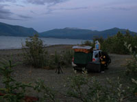 Kluane Lake was quite picturesque, and with the night closing in, we thought of finding a place to sleep. By chance, we found a dirt road turnoff toward the lake. Curious, we drove down to see whether there was some place to camp and found an extinguished fire suggesting someone had either camped or had picnicked here earlier. Although a little apprehensive without anyone else around, we decided to settle for the night next to the lake. Without the rain, it was a snap for us to set up our sleeping arrangement now that we'd done it numerous times. We only had to be careful not leaving any food inside for fear of an unexpected visit by a bear. The night view of the lake was wonderful, the place was quiet except for occasional trucks, and the weather stayed clear through the night. We had one of our most enjoyable sleeps right on the side of Kluane Lake. Kluane Lake was quite picturesque, and with the night closing in, we thought of finding a place to sleep. By chance, we found a dirt road turnoff toward the lake. Curious, we drove down to see whether there was some place to camp and found an extinguished fire suggesting someone had either camped or had picnicked here earlier. Although a little apprehensive without anyone else around, we decided to settle for the night next to the lake. Without the rain, it was a snap for us to set up our sleeping arrangement now that we'd done it numerous times. We only had to be careful not leaving any food inside for fear of an unexpected visit by a bear. The night view of the lake was wonderful, the place was quiet except for occasional trucks, and the weather stayed clear through the night. We had one of our most enjoyable sleeps right on the side of Kluane Lake.
|
|
Photoset from Valdez to Kluane Lake
|
|
Roads and Weather
The road condition was generally good except for the section near the Canada border to Beaver Creek as mentioned above due to permafrost.
The weather started out bad with rain and fog, got progressively better during the day, with one major downpour near the Canadian border. The day ended up with great weather and beautiful sunset.
External Links
Tok Cutoff Highway - wikipedia description, mile by mile description
Other highways and points of interest were in Day 7 and Day 8.
|