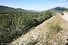
 Our first stop was at a nondescript roadside viewpoint. The view was nice but not exceptional, but the memorable thing was what we did to help another traveler. After taking a few pictures at this place, I noticed a car with headlights on. When we approached to warn the driver, we found a woman deep in her sleep at the wheel. So, risking annoying her, I tapped at the window and let her know about the headlight, and advise her to try to crank the engine. The groggy woman tried it, and sure enough, nothing happened. She almost panicked, but I told her I could help, then 'coolly' brought over our jumper battery. After the engine started, I asked her where she came from and where she was going. It turned out with some breakup in the family, she was on her way from Anchorage to New Jersey - what a distance to travel all by yourself! I wished her well, advised her to let the engine run for a bit longer then headed on our way. The feeling of being able to help someone in need stayed with me for a long time. I felt like being her angle in that brief chance encounter. If I could only have predicted that I would find myself in a similar predicament the following day... Our first stop was at a nondescript roadside viewpoint. The view was nice but not exceptional, but the memorable thing was what we did to help another traveler. After taking a few pictures at this place, I noticed a car with headlights on. When we approached to warn the driver, we found a woman deep in her sleep at the wheel. So, risking annoying her, I tapped at the window and let her know about the headlight, and advise her to try to crank the engine. The groggy woman tried it, and sure enough, nothing happened. She almost panicked, but I told her I could help, then 'coolly' brought over our jumper battery. After the engine started, I asked her where she came from and where she was going. It turned out with some breakup in the family, she was on her way from Anchorage to New Jersey - what a distance to travel all by yourself! I wished her well, advised her to let the engine run for a bit longer then headed on our way. The feeling of being able to help someone in need stayed with me for a long time. I felt like being her angle in that brief chance encounter. If I could only have predicted that I would find myself in a similar predicament the following day...
After an hour or so driving, we made a stop at Rancheria Falls, hoping to find a thunderous waterfalls in this amazing region. Our short stroll led us to a puny waterfalls probably no higher than 10 ft. This detour would be worthwhile for those wishing to stretch their legs after a long drive, but from my view not for photographic purposes.
 Moving on another 15 minutes, we reached the Continental Divide. Unlike the well known Grea Continental Divide in the US which separate watersheds of the Atlantic and Pacific, this northern section of the Great Divide separate water flowing into the Bering Sea of the Pacific Ocean from the Beaufort Seas of the Arctic Ocean. This particular spot is among the lowest elevation of continental divides, which unless called out by the sign I would have assume to be just another sandy hill. Moving on another 15 minutes, we reached the Continental Divide. Unlike the well known Grea Continental Divide in the US which separate watersheds of the Atlantic and Pacific, this northern section of the Great Divide separate water flowing into the Bering Sea of the Pacific Ocean from the Beaufort Seas of the Arctic Ocean. This particular spot is among the lowest elevation of continental divides, which unless called out by the sign I would have assume to be just another sandy hill.
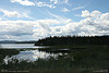
About half way to Whitehorse, we came across the picturesque village of Teslin jutting out of the Teslin Lake and Nisutlin Bay.Like many towns and cities, Teslin became populated during the Gold Rush. Now, this place is home to some 450 people, with fishing naturally as the most popular outdoor activitiy. In the First Nation language of Tlingit, Teslin means "Long Narrow Water", an aptly named lake that is 78 miles long and 2 miles wide. It seemed to take hours to drive beyond its lakeshore.
 Further west on the highway was another long and narrow lake called Marsh Lake, a widen area of the Yukon River some 30 miles long. The name Marsh did not mean marshy or swampy condition. Rather, it was named after a surveyor named Marsh. At the north end of the lake, we made a rather long detour to a place called Swan Haven, a migratory destination for trumpeter swan. We were late only four months and the swans were long gone. Driven by roadside signs and spontaneous decisions, sometimes you hit and sometimes you miss. In this case and Rancheria Falls, they were misses for this day. Fortunately overall, we had more hits than misses. Further west on the highway was another long and narrow lake called Marsh Lake, a widen area of the Yukon River some 30 miles long. The name Marsh did not mean marshy or swampy condition. Rather, it was named after a surveyor named Marsh. At the north end of the lake, we made a rather long detour to a place called Swan Haven, a migratory destination for trumpeter swan. We were late only four months and the swans were long gone. Driven by roadside signs and spontaneous decisions, sometimes you hit and sometimes you miss. In this case and Rancheria Falls, they were misses for this day. Fortunately overall, we had more hits than misses.
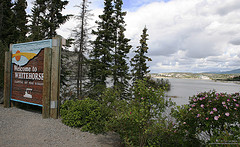 We reached Whitehorse, the capital of Yukon by early afternoon. Having driven days without seeing a large city, we were surprised at its size and mordern facilities this far north. It has a big visitor center, some museums and tons of places to eat and stay, and many other amenities. We visited the McBride museum located at the center of town. This would be a great place to learn about the history of the city, the natural world of the region, and about pioneer life. We even had the chance to attend a short play recounting the Robert Service's poem "The Cremation of Sam McGee", a fictional story of cremating the frozen body of a prospector, but using the name of a real person which in turn caused other interesting drama. Whitehorse is a good place to stay for a couple of days during the long road trip to Alaska. It has a good mix of modern amenities, culture, outdoor activities to let one change the pace of hands on wheel in days fore and aft. Unfortunately, we had time pressure to move on, and so we did. We reached Whitehorse, the capital of Yukon by early afternoon. Having driven days without seeing a large city, we were surprised at its size and mordern facilities this far north. It has a big visitor center, some museums and tons of places to eat and stay, and many other amenities. We visited the McBride museum located at the center of town. This would be a great place to learn about the history of the city, the natural world of the region, and about pioneer life. We even had the chance to attend a short play recounting the Robert Service's poem "The Cremation of Sam McGee", a fictional story of cremating the frozen body of a prospector, but using the name of a real person which in turn caused other interesting drama. Whitehorse is a good place to stay for a couple of days during the long road trip to Alaska. It has a good mix of modern amenities, culture, outdoor activities to let one change the pace of hands on wheel in days fore and aft. Unfortunately, we had time pressure to move on, and so we did.
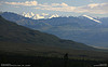
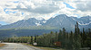 Within an hour and a half after departing Whitehorse, the town of Haines Junction was in our view, dwarfed by moutain ranges in the Kluane National Park. This town is a good reststop to fill up and freshen up. The mountain ranges stayed with us through the rest of the day. Kluane National Park is home to the highest peak in Canada. This park and its Alaska contiguous Wrangell-St Elias National Park make up the largest area of protected land in the world, and is designated a World Heritage Site. Within an hour and a half after departing Whitehorse, the town of Haines Junction was in our view, dwarfed by moutain ranges in the Kluane National Park. This town is a good reststop to fill up and freshen up. The mountain ranges stayed with us through the rest of the day. Kluane National Park is home to the highest peak in Canada. This park and its Alaska contiguous Wrangell-St Elias National Park make up the largest area of protected land in the world, and is designated a World Heritage Site.
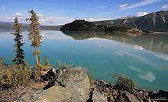 Kluane Lake was sight to behold. It's framed on the eastern side by the Ruby Range and St. Elias Mountains on the western side. The turquoise water was fed by glacier silt from St. Elias Mountains. This lake has a surface area of around 150 square miles, over two-third the size of Lake Tahoe. Fishing sounds great here as the lake was designated a Trophy Lake status, i.e. there is a chance to catch trophy sized fish. We reached this lake past 5 PM and yet the sun was still way up in the sky. My wife cooked while I tried to catch a short nap in preparation for a few more hours drive.By the time we finished eating, it seemed the sun had not moved at all! We were on our way one more time. Kluane Lake was sight to behold. It's framed on the eastern side by the Ruby Range and St. Elias Mountains on the western side. The turquoise water was fed by glacier silt from St. Elias Mountains. This lake has a surface area of around 150 square miles, over two-third the size of Lake Tahoe. Fishing sounds great here as the lake was designated a Trophy Lake status, i.e. there is a chance to catch trophy sized fish. We reached this lake past 5 PM and yet the sun was still way up in the sky. My wife cooked while I tried to catch a short nap in preparation for a few more hours drive.By the time we finished eating, it seemed the sun had not moved at all! We were on our way one more time.
 Soon after Kluane Lake, the road veered north, away from the St. Elias Mountains. There were several road signs warning of uneven pavement due to permafrost. We got into a few bumps, but nothing serious. I suspect people towing trailers might have a more difficult time. We kept going until after 9 PM, and decided to stop for the night at Lake Creek Campground, a short distance shy of Beaver Creek. Including the various visits, we were on the road for over twelve hours. Soon after Kluane Lake, the road veered north, away from the St. Elias Mountains. There were several road signs warning of uneven pavement due to permafrost. We got into a few bumps, but nothing serious. I suspect people towing trailers might have a more difficult time. We kept going until after 9 PM, and decided to stop for the night at Lake Creek Campground, a short distance shy of Beaver Creek. Including the various visits, we were on the road for over twelve hours.
|