|
||||||||||
|
||||||||||
Journal |
Slideshow |
||||||||||||||||||||||||
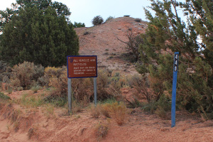
The visit to Grosvenor Arch was originally unplanned but rewarding. I skipped driving to the arch several years ago while visiting The Wave due to the long 30-mile drive on dirt road from Highway 89. This time being at Kodachrome State Park, the distance was much better at 10 miles and the road condition was favorable due to the long dry spell. The drive itself was interesting but I save that for the Getting There section. The Grosvenor Arch area, despite being on dirt road, was actually well developed with wheelchair accessible path to the arch, picnic area with cement table, and a pit toilet. When I got there, the sun was behind the cloud and the color was flat. Taking advantage of the suboptimal photographic condition, I pulled out my mobile kitchen and prepared filtered coffee. Having the entire region to me was a special feeling. There were only shrubs and some low growing trees in the surrounding which allowed unobstructed views of vast distance in all directions. The air was cold and it was quiet. Just for that alone was worth the drive. Just as I finished up the coffee which served dual purpose - waking my senses up and warmed my hands, the sun began poking through the cloud. So the photographer mentality kicked in and I quickly grabbed the camera, tripod and backpack and headed to the arch on the short paved trail. Getting to the arch itself was quick and easy. The last stretch to reach the base of the arch had no trail though. Grosvenor Arch is actually two sandstone arches perching high up a Henrieville Sandstone outcrop. According to US Geologic Survey, it's 152 ft high and 99 ft wide. Photographic suggestion: Not much out of the ordinary. Polarizing filters helps. No need for telephoto. Still not sure when best to be here. The light in the morning was okay but no drama. Perhaps late in the day. Pay attention if you leave the walkway to the base of the arch for kryptobioptic soil clumps that may take many decades to recover. See below. |
|||||||||||||||||||||||||
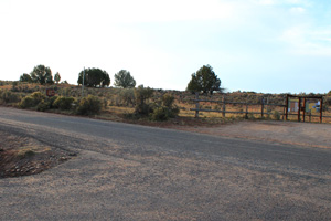
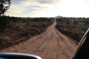
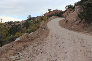
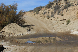
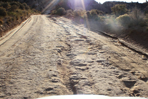
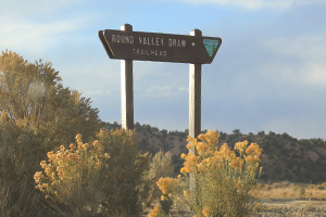
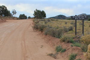
Getting ThereThe drive to the arch was interesting to me; at least I learned a few lessons. First, consult and bring your map. Directions and road signs are few. Assuming a single dirt road to the arch, I drove in paying little attention to the map. Part way through, after a couple of turn offs, I began to wonder whether I was on the right road or should have turned somewhere earlier. Just then a Jeep came back out from the opposite direction. I stopped and asked them whether I was on the right track, only to have the two guys looking back at me in disappointment and said that they were hoping that I could have given them directions! Time to consult the map which fortunately I took one the day before of the Grand Staircase area and there was some numbered dirt roads leading to the arch. With that, I continued on while the other guys went back out to civilization. From that moment on, I kept the map open and confirmed landmarks as I passed them. In the middle of nowhere and with no one to ask questions, a few miles can be a long way. The arch is located about a mile on 440 Road off of the Cottonwood Canyon Road, after passing Round Valley Draw Trailhead among others. The second lesson: Drive carefully and adhere to speed limit. The dirt road was in fairly decent shape when I drove through which was both a blessing and a curse. Assuming generally good driving condition, one can drive at a higher speed than suggested and can really test the shock absorbers when encountering unexpected potholes. Also, flash floods can occur and create rough sections of road in otherwise good condition. I encountered both kinds as well as a section crossing a wash with water still in it. I can imagine how bad the road could be in wet weather. So do consult local BLM offices before heading out on these dirt roads. There were a few stretches when the road climbs through hilly terrains, but nothing hazardous. Third, be careful when driving through water. There is no telling how deep it might be. When in doubt, get out of the car and check first. This one was fine, but be cautious in the middle of nowhere is important. Below are a few pictures to illustrate the points.
|
|||||||||||||||||||||||||
Useful links |
|||||||||||||||||||||||||
|
|||||||||||||||||||||||||