


 Alabama
Hills (10/15-16/2005)
Alabama
Hills (10/15-16/2005)
I read a bit about Alabama Hills before setting out on my Fall Foliage trip. It was also recommended by an older gentleman I met at Mono Lake, who spoke of the multi-hue/interesting rock patterns at Alabama Hills. So I made a point to stop by this area for a visit on my way to Whitney Portal.I’ll add a section at the end for those who wish to go to this location. Be sure to read it if you plan to visit – some experiences were not very pleasant.
Alabama Hills is a couple of miles up the road from Lone Pine on the way to Whitney Portal. It was officially managed by BLM, which allocated some 30,000 acres as the Lone Pine Recreational Area. The name Alabama Hills came about thanks to the Civil War. I found different historical explanation of its origin, but I will trust Wikipedia which states the following: “The Alabama Hills were named for CSS Alabama. When news of the Confederate warship's exploits reached prospectors in California sympathetic to the Confederates, they named many mining claims after her, and the name came to be applied to the entire mountain range. Then, when Alabama was sunk off the coast of Normandy by USS Kearsarge in 1864, prospectors sympathetic to the North named a mining district, mountain pass, a peak, and a town after Kearsarge.” I even found a painting of the CSS Alabama and will post it here as well. Okay, so much for the historical background. Let’s move on to my travelogue.
Unlike the road to Glacier Lodge, direction to Alabama Hills was quite clear. The road was well marked and even has an information turnout. The turnoff to Alabama Hills is Movie Road, so named for the many Western movies made in this area due to the rugged and harsh terrain suitable for cowboys/Indians shootouts. Big names such as Roy Rogers, Gene Autry, Errol Flynn and John Wayne were here at one time or another. There were so many movies made here that the town of Lone Pine dedicates the month of October for the Movie festival. I did not see any, and wonder what venues would be used for such festival given not a lot of movie theaters might be around – none caught my attention anyway. It turned out that real Indian-settler shootouts took place in this very region in the 1800’s.
Even after reading the local pamphlets on Alabama Hills, I still had to seek more information but got no advice from the local hotel I was at as to where to go or what I should focus on. Perhaps if I took the time to look for the visitor center, I might get more useful guidance. I went to Alabama Hills with just a hand-drawn map which turned out not to be very useful. Aside from the “Face” Rock which was defaced by someone who painted a face on it, I did not locate the rest of the interesting rock formations. There were not many information sign of what part of the area I was at, or where to find certain rock formations or movie sets. Still, there were plenty of interesting looking rock formations to try your photographic or painting creativity. I reckon some good research would be necessary to find out exactly where to go, what to look for, and at what time of the day to be there in order to capture the right moment. For me, it seemed that none of the moments were quite right. I managed to capture fairly reasonable pictures, but the midmorning light one day, and the cloud covered Sierra range the second did not make it easy to make decent compositions.
 Alabama
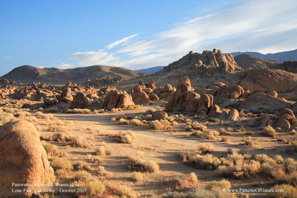
Hills landscape is desolate, with not many trees to speak of. There were
plenty of rock formations of various shapes and sizes. Having been to
Joshua Tree National Park, Alabama rock formations did not impress me
in size or volume. [My subsequent research of the geology of the area,
it appears that what we see are just outcrops of a much deeper rock system,
with the tip of the iceberg being a fair analogy]. However, there were
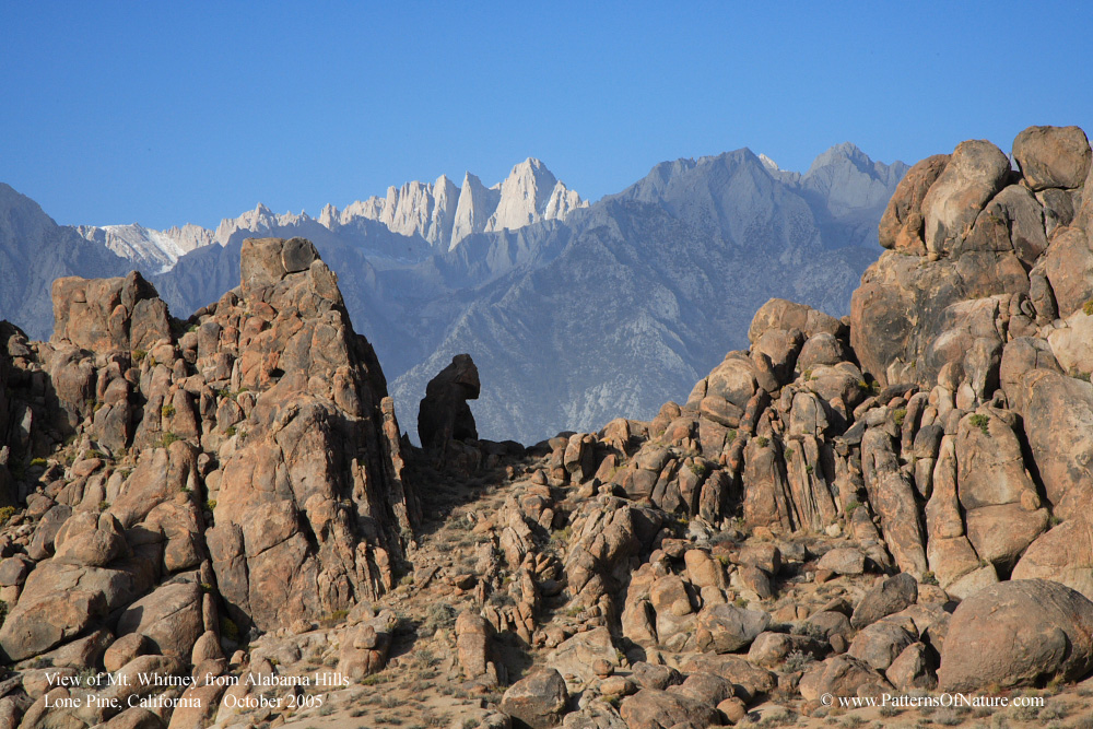
a few small granite arches that made it interesting. Further, the backdrop
of Mount Whitney and other peaks of the Sierra made it interesting for
photographic purpose. It was advertised that night time photography here
would turn out great, but the storm hitting the area that night did not
give me the opportunity to try my luck.
Alabama
Hills landscape is desolate, with not many trees to speak of. There were
plenty of rock formations of various shapes and sizes. Having been to
Joshua Tree National Park, Alabama rock formations did not impress me
in size or volume. [My subsequent research of the geology of the area,
it appears that what we see are just outcrops of a much deeper rock system,
with the tip of the iceberg being a fair analogy]. However, there were
a few small granite arches that made it interesting. Further, the backdrop
of Mount Whitney and other peaks of the Sierra made it interesting for
photographic purpose. It was advertised that night time photography here
would turn out great, but the storm hitting the area that night did not
give me the opportunity to try my luck.
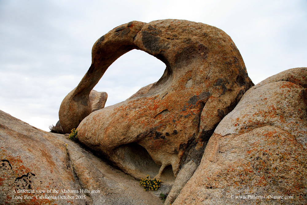 One
reasonably wise thing I did was to capture on my high-resolution camera
directions to go to the 2 arches in the area. This enabled me to review
the direction carefully and was able to find them on the second day when
I returned from Whitney Portal. These arches are quite small compared
to those I saw in Utah, but these are of the type idioblastic metamorphic
rocks which are different from those sandstone rock arches in Utah. Someone
with more knowledge should correct if necessary.
One
reasonably wise thing I did was to capture on my high-resolution camera
directions to go to the 2 arches in the area. This enabled me to review
the direction carefully and was able to find them on the second day when
I returned from Whitney Portal. These arches are quite small compared
to those I saw in Utah, but these are of the type idioblastic metamorphic
rocks which are different from those sandstone rock arches in Utah. Someone
with more knowledge should correct if necessary.
On a clear day or moonlit night, or even at sunset, I can imagine this
being an excellent photographic subject since it frame the Sierra range
and Mount Whitney quite nicely. The arch alongside Whitney Portal Road
would take reasonable effort to get to. I’d give it an hour for
getting to it and back, with some time for taking pictures. Once there,
it’s not easy to frame Mt Whitney inside the arch. With some acrobatic
and risk-taking maneuvers, one can achieve that framing effect though,
as you’ll see in my posted pictures.
Overall, it was a nice side trip. I can imagine camping in the area overnight
and try to capture sunrise, sunset and moonlight pictures.
Some pictures I took are posted HERE.
Advices for those who want to visit Alabama Hills
Following are some personal tips on making the best of your visit. Most
people probably don’t care for this type of information.
1. Make sure you stop by that information turnout since it gives information
about how to get to 2 nice arches.
2. The direction to one arch in the Movie Road area was clear. One just
needs to find the right arch. I found a small one and thought that was
it, but later found a larger arch hiding behind a large boulder.
3. Direction to the arch alongside Whitney Portal Road was not quite clear.
One can actually see the arch from the trail and don’t need to be
in the wash. The simplest thing to do is to follow along the fence until
it ends. In another 50 yards or so past the end of the fencing, you should
see the small arch on top of the hill to the right. Keep that in you sight
as you navigate through brushes to get there. One minor tip – climb
up the ravine in between the two hills leading to the arch – it’s
easier that way. Once there, you’d need to be tall to climb the
fins to frame Mt Whitney in your picture, or climb it carefully [like
I did ?]
4. If you’re interested in finding the exact movie sets, bring a
detailed map along and note where you are along the way. The lack of roadsigns
and similarities of the landscape makes it difficult to pinpoint your
location. As I hone my hiking experience, giving GPS coordinates would
be more accurate.
5. Drive around first one afternoon without taking pictures to get a sense
of the place and make a mental note of sun/moon movements so you can be
at the right place/right time.
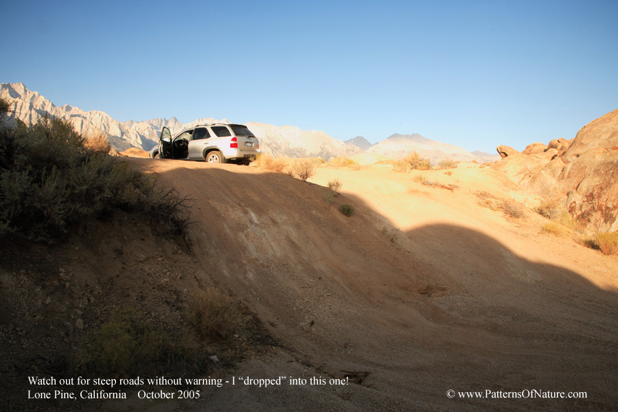 6. The roads are primarily dirt road with the major roads easy to drive
although dusty. Watch out for side dirt roads. Many of them might not
have been roads in the first place, but created by adventurous 4-wheelers.
I found several that dead-ended. Some were quite narrow, and I literally
“fell” into one steep one that dead-ended shortly after. Make
sure to check out the side dirt roads before you drive on it too far!
6. The roads are primarily dirt road with the major roads easy to drive
although dusty. Watch out for side dirt roads. Many of them might not
have been roads in the first place, but created by adventurous 4-wheelers.
I found several that dead-ended. Some were quite narrow, and I literally
“fell” into one steep one that dead-ended shortly after. Make
sure to check out the side dirt roads before you drive on it too far!
7. It would be prudent to bring along a walking stick and a pair of gloves
if you intend to climb seriously. The rock surface in this region is very
abrasive. It’s not smooth at all. Also, walking downhill on steep
hills can be slippery due to rock erosion. [Those who read my trip report
to Glacier Lodge might find it amusing that I even know the term “prudent”].
Home About Us Friends Family Copyright
Last updated: October 17, 2010