Driving to Alaska has always been one of my dream adventures. First, I was intrigued with visiting “The Last Frontier” where the land mass is a fifth of the size of all other US states combined, where the landscape is unlike anywhere else in the US, where the sun never sleeps in the summer for northern areas, where grizzlies roam the forest, where humpback whales breach and where glaciers meet the seas. In addition to visiting such place of mystique, taking on the long journey by car would bring another level of adventure since few have taken on such journeys. Driving through the vast Yukon Territories was unlike cross-country car trips in the lower states where one can just follow interstates, fill up gas whenever running low, sleep in comfort and safety whenever one feels tired, and within shouting distance of help most of the time. Having to deal with the unknowns of the drive in the maiden voyage to the last frontier would give us the highest sense of excitement within our abilities.
Having the intent to go the land route was only the first step. It was not easy just to pack up and drive to Alaska. Just the distance being similar to driving across the US and back means many logistical matters must be addressed. The roads in western Canada are not familiar to most, and my research suggested there are hazards to consider such as poor road surface, frequent maintenance, and unpredictable weather. Therefore, we need to prepare to deal with issues we might encounter en route. We also needed to weigh the cost aspect by evaluating costs of a driving tour relative to typical Alaska travel approaches such as flying+driving or taking a cruise+tour. In the end, it was the sense of adventure that took over even though we might be able to see Alaska with less time and money by taking a cruise-tour.
Research and planning eventually yielded a sketch of itinerary without firm commitment to specific stops or date. This itinerary would take us from California to British Columbia, winding our way up through the Alaska Highway through Yukon into Alaska, with visits in Fairbanks, Denali, Anchorage and several coastal towns before heading back either via ferry or retracing part of the route.
We would travel in our SUV, and organize it such that we would extend the cab for tent space so that we can setup and take down quickly.Having settled on the plan, our effort switched to getting ready for the trip. This involved having our SUV serviced for long distance driving, ensuring we can camp with efficiency and safety, adequate food supplies, and clothing for different weather conditions that we might encounter. The biggest challenge of all is to prepare for all that within the confine of our SUV. We ensured our SUV was in good condition for a long voyage. Most importantly, the tires and engine must be in top working condition. We also prepared the back of the SUV as an extended cab for camping purpose, both for convenience of quick setup and takedown and for safety reasons in the event wild animals pay us a visit. We need to have the right clothing for different weather, from dry to wet, from warm to cold. We needed to pack food so that we’d be self-sufficient for a few days, and without refrigeration. Perhaps the biggest challenge is to do all this within the confine of the SUV.
With all the dreaming, researching, planning, preparing and procastinating over with, we finally embarked on this journey in July 2010 after I took early retirement. By the time we parked the car back on our driveway, we had logged some nine thousand miles of travel from California to Canada, through the British Columbia and Yukon Territories, into Alaska central and southern coastal regions, back through the Alberta Province before circling back to the US. We met most of our expected goals and managed a few unexpected ones as well.
This post series recaps what we saw and loved and the experience of the drive getting there with the intention of offering insights of our experience to those who might be contemplating similar journeys. In general, the posts follow the outline described below.
Planning and preparation – This covers our thought process leading to making the trip, concerns we became aware of, and the sketch of our itinerary. It also covers what we did before setting out, including servicing the car, packing food, luggage, preparing for car camping, all to fit without requiring a trailer.
Day-by-day journals – This is the meat of the series, covering the journey from day to day, with highlights of what we see along the way, issues we had to deal with, and how we felt about the day. The map on the left is my first effort making use of Google Maps. I found it to be the best tool, that despite some issues which I expect to get resolved soon, provides great features to document this extensive journey with points of interest, photos and videos. As I learn the tool and key tool issues (there are some key ones to my surprise for such a well known product) are addressed, the Map View should provide a new way to navigate the day-by-day journals.
Driving & Weather experience – For impatient people, reading through day by day journal to glean our driving experience might be too much to bear, so we’ll summarize only the driving experience where there was something noteworthy for the driver.
Highlights what we did, what we liked or disliked, and key lessons we drew.
Be warned - This being a long journey with many stops, it will take a while to complete.
Following is a quick snapshot of our journey. For more detailed account of driving condition, weather, interesting stops and so on, see the Day By Day Journalssection.
We set out one day before the middle of July.
The first day, while uneventful, was probably the most important since only then that all the planning and preparation effort leading to that point began to bear fruits. Sticking to our plan of traveling as far north as possible, we only made one stop in Salem, Oregon to visit the state capitol before heading on and stopped after we reached Washington.
We ended the second day at North Cascades National Park and camped overnight. Hiking in the rain, sleeping under the rain and preparing breakfast in the rainquickly got us out of our routine and into the adventure mood. After a nice hike to Thunder Knob, we headed north. Skipping Vancouver where we had visited previously, we followed to the picturesque highway 99 to Whistler for a night rest. Highway 99 to its end at Highway 97 was quite stunning, full of lakes, mountains, glaciers and waterfalls. The drive along Highway 97 was easy and flat.
The journey north continued with similar vista of rolling hills and farmland. We stopped for a late lunch to explore the town of Dawson Creek. Its historical significance was the start of the Alaska Highway. We embarked our journey on the Alaska Highway and camped on the bank of the Buckinghorse River under the rain.
Continuing on the Alaska Highway under the rain, we reentered mountainous terrains with beautiful lakes and mountains. Traffic thinned considerably. We made a short stop at Muncho Lake, claimed as one of the most beautiful lake of the world. Some roads during this section were under heavy maintenance, slowing down the pace. We drove until late in the evening and camped at a RV campground just north of Watson Lake. We stopped at Whitehorse for lunch and paid a visit to the large Visitor Center there. While the city was nice and well equipped for tourist, we were more interested in reaching our destination and thus kept on driving to Beaver Creek.
The drive to the border with Alaska was when we really experienced the much warned permafrost damaged roads, where the thawing and freezing of the soil created uneven pavements. We felt bad for larger vehicles, especially those towing. Surprisingly, we were not that impressed with the views along the Alaska Highway in Alaska. Many vista points along the road were of marsh lands. Our first mishap of the journey was in this section of road when we let our guard down and assumed that we’d find gas along this major corridor to Delta Junction. With the help of the Postmaster at Dot Lake, we got some gas and moved on, being more care to fill up when the gas tank was just less than haft-tank full.
Our stop in Fairbanks was quite nice, with visit to the famous Museum of the North at the University of Alaska Campus and a riverboat cruise to learn about Athabascan Indian culture.
We next visited Denali National Park and took a park tour into Denali wilderness to see wildlife and got a peek at Mount McKinley.
The road south to Anchorage was full of maintenance activities, making traveling a rather short distance a full day affair. We did not get too much of the feeling of the “Last Frontier” while driving south of Fairbanks.
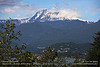
Anchorage is the largest city in Alaska by at least by an order of magnitude. We visited the Alaska Native Heritage Center to learn more about life of native people, and the Anchorage Museum before continuing south. The drive on Seward Highway was full of beautiful scenic viewpoints of the bay and glaciers. This is the beginning of our many “wow, this is the best place we’ve seen on the trip”.
Kenai was a nice relaxing town with a historic district, and where dip netting seemed quite popular.
We went all the way to Homer, but found the place with too many people, RVs and so on. We decided to skip a day there and headed back toward Kenai. Seward was our next stop, and the first place where we got close to a glacier. The Kenai Fjord boat tour was one of the highlight where we encountered plenty of marine wildlife.
With the rain not letting up, we retraced our way back and headed toward Valdez. The highways leading to Valdez were even more picturesque than what we saw previously. Near Valdez, we found Worthington Glacier that was accessible by car. To our surprise, Valdez was also full of tourists. We were lucky to find a place to stay that resembled a ship container to keep us from the relentless rain.
Being fed up with the rain, we headed back toward Canada hoping for better weather. Driving as far as we could, we found a beautiful pullout next to Kluane Lake and camped out for the night. This was the first time during the trip that we were all by ourselves, and woke up to beautiful sunrise across the lake.
We made a spur of the moment decision to drive toward Skagway to ride the Yukon-Whitepass Railroad Tour. Skagway was a good historic town, but also full of tourists from cruise ships when we arrived, then within a few hours became deserted when the cruise ships left.
With the intended route closed by wildfire, we made another big decision to drive further east into Alberta to visit Jasper and Banff National Parks in order to avoid traveling on the same monotonous route all the way back to the US.
The road to Jasper National Park was nice but not comparable to those we had seen. Sections of the highway were full of potholes. The city of Jasper was quite vibrant and full of tourists. Arming ourselves with good information from the visitor center, we headed out to visit several iconic landmarks. Lake Louise itself was a letdown for us with so much anticipation. In the middle of the summer, the place was packed with tourists. It took us several passes in the big parking lot to find a place to park. The scenery was absolutely stunning, with lake boundaries formed by mountains with glaciers.
Having seen Lake Louise, we got in the mood of heading home and drove as far as we could toward the US. The rest of the journey was mostly about driving. There were beautiful places that we could enjoy, but we kept on driving and arrived home in just over 2 days.
Driving condition
Despite warnings found from web research, I still found myself surprised both positively and negatively as we drove the length of the journey. We found that most of the highways were reasonably well maintained well into the Yukon Territorries. They were in better condition than we had envisioned we'd have to endure. We found the worst stretch to be from Beaver Creek to beyond the Alaska border, where there was no more Canadian towns. We joked that the Canadian knew where to put their maintenance money. The innumerable road repairs in both Canada and Alaska caused substantial delays and frustration at times. During this trip, we drove on all types of roads from interstate quality to dirt roads.
Weather
It turned out that the weather played the single biggest role on changing our journey. About one-third of the time we spent in Canada and two-third in Alaska was under rainy condition. This caused us to cut short many visits in Alaska, and prevented activities we would have taken or reduced enjoyment when we braved the weather to do something. Alaskans said what we experienced was not the norm and they were sick of it as well. It was the weather that caused the mud slide closing the Top of the World Highway that prevented our journey further north and would cause us to retrace our route. A wildfire closed Highway 37 in Yukon- the only alternate route south from the one we took. These weather related issues forced us to change our plan and had to retrace our path for over a thousand miles. We then added another thousand miles so that we could see something different from the same vista on the way up. On the positive side, we would not have seen the great sceneries Jasper and Baff national parks had to offer without the big detour. We really enjoyed our trip even with the rains, but it could have been great.

 Day-by-day journals
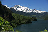 We ended the second day at North Cascades National Park and camped overnight. Hiking in the rain, sleeping under the rain and preparing breakfast in the rainquickly got us out of our routine and into the adventure mood. After a nice hike to Thunder Knob, we headed north. Skipping Vancouver where we had visited previously, we followed to the picturesque highway 99 to Whistler for a night rest. Highway 99 to its end at Highway 97 was quite stunning, full of lakes, mountains, glaciers and waterfalls. The drive along Highway 97 was easy and flat.